Guide to Noto’s Satoyama and Satoumi (Globally Important Agricultural Heritage Systems) by Photos and Movies


Name
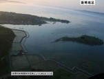
Land Reclamation at Ôchigata
Address
Hakui City 〜 Nanao City
Category
Natural landscape
Class
Landmark
Age
20th century~21th century
Comment
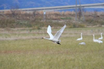
A band of flat land called Ôchigata Rift Valley stretches from Nanao Bay to Hakui City. Ôchigata Lagoon is at the west end of the hollow place created by Sekidozan Fault and Bijozan Fault, which run in parallel. Legend has it that Orochi (a monster serpent), which Ôkuninushi-no-mikoto, the deity to which Ketataisha Shrine in Hakui City is dedicated, defeated, lived there in the mythological age. The name of the lagoon is said to have come from Orochi. The lagoon is about 1.1 km2, and is located where the Kanemaru River, the Nagaso River, the Iiyama River, and the Yoshizaki River flow towards one another. The water flows into the Sea of Japan through the lower reaches of Hakui River. Between 1658 and 1661, reclamation works were implemented under the control of the Kaga domain. From the postwar years 1948 through 1968, government-run reclamation work was carried out, which converted most of the lagoon into agricultural land. During the winter the lagoon becomes a stopover or wintering site for wetland migratory birds such as geese and ducks, and it is famous nationwide for the large number of swans that fly there.
Views
Access number:10841
- Keeper:―